Powder Project Logo

Shell Canyon backcountry.

A A

Your Rating: Rating Rating Rating Rating Rating      
Your Difficulty:
Your Favorites: Add To-Do · Your List

0.7

Miles

1.2

KM

Ski Line

9,325' 2,842 m

High

8,499' 2,590 m

Low

0' 0 m

Up

827' 252 m

Down

22%

Avg Slope (12°)

24%

Max Slope (14°)
Type: Backcountry or Sidecountry

Overview

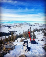
Skin up and ride down in the same area. Typically, there are some sled tracks that might offer a more mellow ascent. The top of this descent can form a cornice, and just below the ridge, you'll find the line's steepest section. If it looks sketchy, trust your gut.

Description

From the top, this line drops you into steep n' deep turns, through a small stand of trees, then out into a short catwalk section.

Of course, this is just one line of many that can be done here, and one could spend an entire day getting freshies if you hit it just right.

Additionally, Antelope Butte is right across the highway.

Contacts

Shared By:

A A

Trail Ratings

  4.0 from 1 vote

#482

Overall
  4.0 from 1 vote
5 Star
0%
4 Star
100%
3 Star
0%
2 Star
0%
1 Star
0%
Ski Line Rankings

#30

in Wyoming

#482

Overall
23 Views Last Month
698 Since Apr 21, 2018
Difficult Difficult

0%
0%
0%
0%
100%
0%

Photos

On top of the Moonlight Peak tons of lines and a bowl off to the northwest
May 6, 2018 near Greybull, WY
Moonlight Peak
Apr 21, 2018 near Greybull, WY
Starting to climb up the steep section to reach the submit Summit.
Apr 21, 2018 near Greybull, WY
Catwalk Section
Apr 21, 2018 near Greybull, WY

0 Comments

6,000 characters
6,000 characters

Weather


Current Trail Conditions

Unknown
Add Your Check-In

Check-Ins

none
PrevNext
April 2025
SuMoTuWeThFrSa
  12345
6789101112
13141516171819
20212223242526
27282930   
Welcome

Join the Community! It's FREE

Already have an account? Login to close this notice.